 A review of
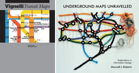
Vignelli Transit Maps
By Peter B. Lloyd and Mark Ovenden
Underground Maps Unravelled: Explorations in Information Design
By Maxwell J. Roberts
Around the world, millions of people rely on diagrams to aid them in navigating subways. Technically speaking, these diagrams are often not maps. Yet these examples of mass rapid transit information design and visualization are now accepted techniques of providing travelers with just-in-time assistance. The general public and professionals from many disciplines should celebrate the challenges and achievements of their usable, useful, and appealing designs.
In 1977, I organized one of the first-ever subway diagram exhibits displaying global examples at the American Institute of Graphic Arts in New York City. Many decades later, two excellent books are available that explore the history of these diagrams in general, and those of one noted design firm in particular.
Underground Maps Unravelled is a detailed and fairly complete discussion of subway diagrams. It records their emergence in London’s Underground at the beginning of the twentieth century in the sketches of Henry Beck, an engineer. It also describes their evolving conventions over decades of experimentation, some eventual industry standards, the challenge of international use, and occasionally playful ornamentation of fundamentally functional visual communication media.
The author examines the minutiae of topology, node and link depictions, angles, visual rules, and how to achieve geometric simplicity, coherence, harmony, and balance. These details might not appeal to those who are not practitioners, fans, or devotees, but the many visual examples clarify the issues within the scope and magnitude of the discussion.
Some usability professionals may notice the lack of detailed reports on testing. Although tests have been performed, quantitative data are not reported much. The book’s perspective focuses on visual syntax and semantics, the varieties of possible arrangement of parts, and the general clarity of sources. References to some of the original rules of placement of stations and lines according to some spatial grid show the emphasis on designing an illustrative system that easily depicts many peculiarities of actual cities and topography.
One notable limit to the investigation is the emphasis on printed media, which certainly was appropriate for the first century of such diagrams. A future chapter or book might delve into interactive, electronic displays that now populate many stations worldwide.
The author correctly points out the need to achieve both aesthetic and functional success; that is, a successful user experience. He calls for more explorations and investigations to achieve a comprehensive theory of diagram design for this crucial communication medium.
The authors of Vignelli Transit Maps focus on New York City’s underground diagrams and those of one particular designer, Massimo Vignelli.
During the 1977 exhibit of global underground diagrams, the “Great Subway Diagram Debate” was staged at Cooper Union in New York City. People discussed the Vignelli diagram, which was introduced in the late 1960s. This diagram featured multiple lines, each representing a train (a very simple, “modernist,” geometric visual style), the use of simple white and gray areas for land and water, and the use of Helvetica typography throughout the diagram.
A new proposal, pitted against this design approach, returned to traditional green parks and blue water. It also used a single line depiction with multiple symbols to represent all the different services of trains at different times of day, different routes, for example, express versus local. After the debate, the Metropolitan Transit Authority decided to use the conservative, traditional depiction.
The lead designer presents a modern-day discussion of the history of his design. He also considers his predecessors and debates issues about geometric, diagrammatic depictions versus the more conventional cartographic, geographic, spatial depiction (on top of a map). The conventional design was the original depiction style of the London Underground before Beck’s invention of a more topological approach, which kept the correct connections but enlarged the center of the city to show the multitude of stations.
Vignelli Transit Maps provides fascinating, detailed historical narrative. The authors, along with Massimo Vignelli himself, describe the visual, functional, social, political, and economic factors that influenced the design. After thirty years, it delivers a new redesign effort based on the classic Vignelli diagram. Professionals and students should find value in the discussion of how to develop such a diagram.
The Vignelli blueprint has become an icon of this design style for its elegance and simplicity, and yet is probably still vilified by others for its break with tradition. Reading through this history is fascinating and informative.
Between both of these books, one has an immediate overview of this visual communication domain and a structured, thoughtful analysis of the design issues that challenge today’s professionals.
关于《地铁地图详解》(Underground Maps Unravelled) 和《维格纳利交通地图》(Vignelli Transit Maps) 的书评。对当今专业人员面临的设计问题的分析。
全世界有数百万的人依靠地图的辅助乘坐地铁。《地铁地图详解》(Underground Maps Unravelled) 对地铁地图进行了详细全面的讨论。它记录了伦敦地铁地图在二十世纪初诞生的过程。《维格纳利交通地图》(Vignelli Transit Maps) 的作者重点讨论了纽约市的地铁地图。从这两本书中,读者可以很快获得关于视觉交流领域的概览,了解如何对当今专业人员所面临的设计问题进行结构化的细致分析。
Underground Maps Unravelled 와 Vignelli Transit Maps 에관한서평. 오늘날의전문가가 당면하는 디자인 쟁점에 관한 분석. 전 세계 수백만 명의 사람들은 지하철 이용에 도움을 얻기 위해 노선도를 필요로 합니다.
Underground Maps Unravelled는 지하철 노선도에 대한 자세하고도 매우 완벽한 논의입니다. 20세기 초반 런던의 지하철에 노선도가 등장하던 당시 상황을 기록하고 있습니다. Vignelli Transit Maps의 저자들은 뉴욕 시의 지하철 노선도를 집중적으로 다룹니다. 이 두 권에서는 오늘날 전문가들의 난제가 되는 디자인 쟁점에 대한 체계적이고 사려 깊은 분석과 이러한 시각적 전달 영역에 대한 간략한 개요가 다뤄지고 있습니다.
Uma resenha dos livros Underground Maps Unravelled e Vignelli Transit Maps. Uma análise dos problemas de design que desafiam os profissionais de hoje
Em todo o mundo, milhões de pessoas dependem de mapas para auxiliá-los no transporte em metrôs. Underground Maps Unravelled é uma discussão detalhada e razoavelmente completa sobre os mapas dos metrôs. O livro registra o surgimento dos mapas no metrô de Londres no início do século vinte. Os autores de Vignelli Transit Maps analisam os mapas dos metrôs na cidade de Nova York. Com os dois livros, temos uma visão geral imediata desta área da comunicação visual e uma análise ponderada e estruturada das questões de design que desafiam os profissionais de hoje.
O artigo completo está disponível somente em inglês
『Underground Maps Unravelled 』と『Vignelli Transit Maps』、今日の専門家たちを挑発するデザイン上の問題を分析。
世界中で何百万人もの人々が、地下鉄で移動する際の補助として、路線図を頼りにしている。『Underground Maps Unravelled』は、地下鉄路線図について詳しく、実に徹底的に議論している。路線図は20世紀初頭にロンドンの地下鉄で出現したことが記録されている。『Vignelli Transit Maps』の著者たちはニューヨークシティーの地下鉄路線図に焦点を当てている。これらの2冊で読者は、このビジュアルコミュニケーションの領域の即時的概観と同時に、今日の専門家たちを挑発するデザイン上の課題について体系的かつ慎重に検討された分析を識ることができる。
Una reseña de los libros Underground Maps Unravelled y Vignelli Transit Maps. Un análisis de los aspectos del diseño que generan un desafío para los profesionales de hoy.
Alrededor del mundo, millones de personas confían en los diagramas al navegar el el metro. Underground Maps Unravelled es un análisis detallado y razonablemente completo de los diagramas de metro. Registra la aparición del metro de Londres a principios del s.XX. Los autores de Vignelli Transit Maps se centran en los diagramas del metro de la ciudad de Nueva York. Entre ambos libros, se puede lograr una visión inmediata de este tipo de comunicación visual y un análisis estructurado y bien pensado de los aspectos del diseño que desafían a los profesionales de hoy.
La versión completa de este artículo está sólo disponible en inglés